
In our wonderful hobby, finding a place to dig can take as much time as wandering around with a device in the area. Every experienced digger knows this and every new treasure hunter understands this very quickly. Mende, PGM, Red Army, relief and elevation maps, just satellite Google and Yandex, all this is examined in detail and scrupulously for hours. Everyone has their own algorithm for finding new places, usually it comes with the understanding that everything that is indicated on Menda has been knocked out, re-knocked out, and, to boot, dug up by pits for about ten years. However, I often hear stories about some secret ancient maps that depict disappeared villages, monasteries and even entire cities. These stories begin with stories about a certain successful digger, who goes digging exclusively alone and he digs very successfully because he has a map of the province, which no one else has. Further, the story may vary in its plot, on the topic of how and where this most successful digger got hold of this card. It seems like his wife works in the regional archive, or his dad is a former archaeologist, or his grandfather was an Honored Geographer of the USSR. Sources may be different, but storytellers always agree on one thing – the unique map remains in one copy, and it will be possible to dig on it for many years to come. Not a map, but a complete Eldorado, not to be confused with a chain of stores. I tried to understand the history of Russian cartography and understand how the myth of the “golden” map can be a reality.
Let me note right away that the topic of domestic cartography is material for a full-fledged textbook of four hundred pages. Therefore, I had to try very hard to describe the topic objectively, but at the same time not go into the depths of specialized terms, concepts, names of the founding fathers and listing the disputes of scientific schools. Let’s start with the basics. According to experts in the field of domestic cartography, in the period from 1478 to 1700, ten original maps of Muscovy, Rus’ and the Russian kingdom were created. It is this period that I will try to analyze in this material. Please pay attention to the word “original”. Why? Because you need to immediately understand that cartography is an industry in which plagiarism is very popular because it is difficult to prove. In all kinds of collections, almanacs, cosmographies, atlases and other collections of European and world maps of the 15-16th centuries, the maps themselves were the same, only the descriptions, engravings and images of sea monsters on white geographical spots differed.
Map of Muscovy 1525. The earliest woodcut depicting the territory of the Russian kingdom. The drawing was discovered in 1993, unfortunately, I was unable to find information about how and where the card was discovered, just as there is no information in open sources about the amount for which the card was purchased from the owner at the Sotheby’s auction.
What you need to understand at the very beginning of studying the history of Russian cartography? In Russia, the creation, compilation and production of maps took place exclusively by order of the sovereign. Whereas in Europe, cartography was a highly profitable private enterprise. And in this difference lies a whole series of features of the maps of Muscovy and the Russian kingdom of the period we are studying. All maps of Russia known for that period can be divided into three main groups.
— maps created by foreigners who did not visit Muscovy and the Russian kingdom.
— maps created by foreigners who visited Muscovy and the Russian kingdom.
— cards created by order of the Russian tsars.
Why did I decide to divide the maps of the period under study into these three groups? Probably because the compilers of the maps pursued their own separate goals, and therefore the maps themselves can and should be considered based on the goals that guided the authors of the maps. Separately, it should be pointed out that at that time maps were not published as separate drawings, but as part of collections and accompanied by written comments and descriptions of the political, cultural, economic and other aspects of life in a particular region, state or province depicted on the map itself. And sometimes these comments and descriptions are more valuable material for historians than the ancient maps themselves. While analyzing the material on a given topic, I saw how easily many armchair historians believe the descriptions and the ancient maps themselves. But more on that a little later.

Map of Eastern Europe from the first edition of Cosmography by Sebastian Munster
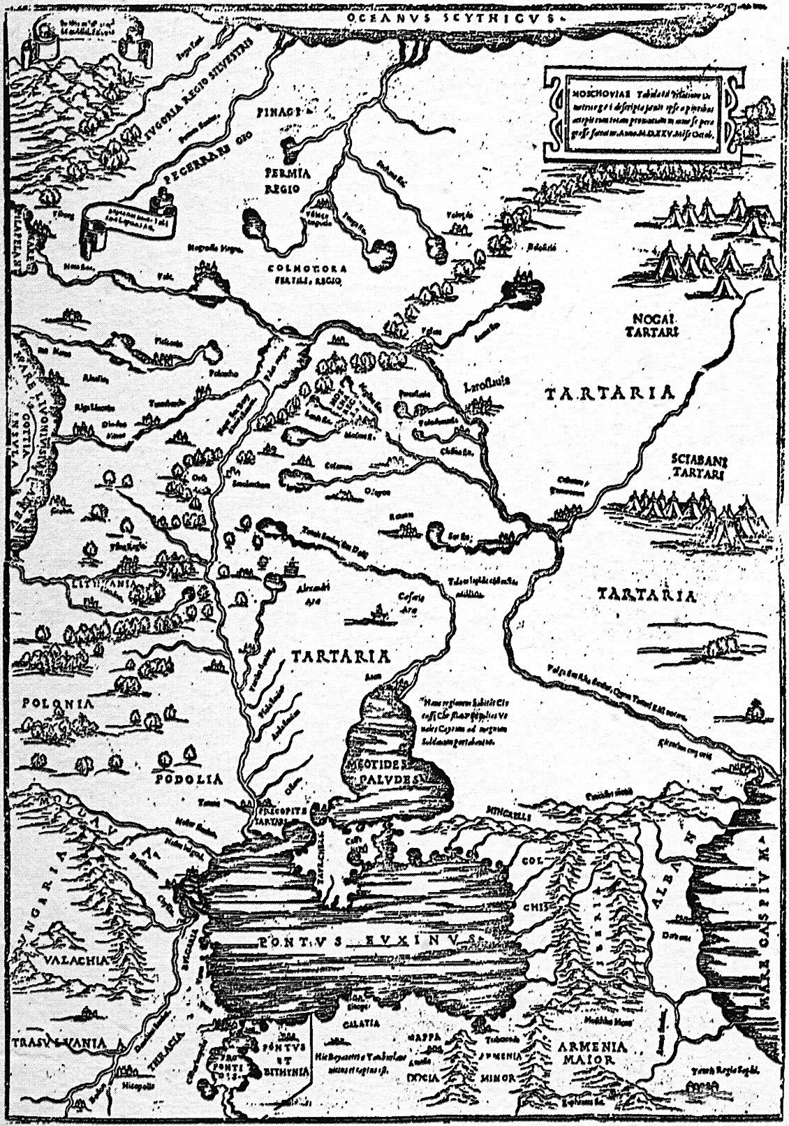
To the first group of maps that were created by European cartographers who did not visit Russia, we can safely include all the maps created on the cosmography of S. Münster published in the city of Basel in 1550. In the 16th century, cosmographies were collections of maps with descriptions, engravings and comments by the author. For example, S. Munster’s Cosmography consisted of 1,100 pages, three of which were allocated for a map of Muscovy and a brief description of the life, customs and traditions of the Muscovites. What can we see useful for ourselves when considering this map? Well, probably only that this is the first map of Muscovy, which is more reminiscent of a metro map or an evacuation plan. But the inquisitive gaze of lovers of historical conspiracies will always find something on such maps. What exactly they can find there is not important, the main thing is that there is something there. For example Tartaria. Not Tataria, but specifically Tartary with an “r”. And then there is Great Perm, Scythia and Sarmatia.
And here you need to go a little into the history of European cartography in order to understand where Scythia, Sarmatia and other names came from on the map of Muscovy in the 16th century, haunting a large number of supporters of the alternative history of our fatherland. And it was like this. With the development of maritime and continental trade, during a period of unprecedented growth in travel, what historians would later call the Age of Discovery. At this very time, consumer demand for maps in Europe increased to the level of demand for the Bible. Demand always creates supply. That’s why Europe is experiencing a boom in cartography. In conditions of fierce competition, those who provide not more accurate maps win, but those who, in one publication, provide the most complete of all possible collections of maps of the countries of the known world. And if you can still travel quite calmly today using maps of continental Europe from that period. Maps of Europe were very accurate and detailed. Today, from the maps that were placed in collections, so to speak, in addition, today only general information can be understood and this needs to be checked several times.
For example, in the original version of the Munster Cosmography, in the section describing Muscovy it is said that the Muscovites have no silver money at all. And they choose their ruler at a general meeting. As researchers and historians subsequently established, regarding the election of the prince, Münster made a mistake in taking information about Novgorod, but regarding the lack of silver money, he simply received an inaccurate translation, since in the material that he took as the basis for his work, and the source was in Italian language, it was written that the Muscovites had money made of pure silver. In general, the cosmography of Munster is of interest for detailed study because until recently, it was this geographical collection that contained the earliest of all known maps of Muscovy and Rus’.
In fact, many serious scientific works have been written on the topic of the entire Cosmography of Munster in general and on the eastern territories of Europe separately. As befits serious scientific works, these works are boring and in some places understandable only to specialists. And this is one of the reasons why it is so easy for the average person to plant another crazy idea on the topic of a terrible historical conspiracy into their consciousness. Let’s look at one such example. In the earliest edition of cosmography on the territory of Eastern Europe, the author placed the lands of two peoples — Scythia and Sarmatia. And here the question arises. How on the map of the 16th century there appeared peoples whose historical mentions are limited to the 6th century AD? Another historical conspiracy? The Germans under Catherine the Great rewrote manuscripts? And you can’t argue? Drawn, and even and drawn by European scientists, and we have more faith in them than in our own academicians. Do not take the latter as my point of view, just sarcasm caused by frequent discussions both with comrades and in threads of various thematic forums.
When studying ancient and medieval historical sources, it is important to understand what sources the authors of that time used to write their scientific works. Sebastian Munster himself compiled most of his cosmography on the basis of earlier works. This is quite common practice in cartography. Copyright applied exclusively to text documents, so the outlines of the maps themselves were transferred from one edition to another, making only some changes based on new data obtained. And here, please pay attention, Scythia and Sarmatia appeared on the map of Eastern Europe from the map of the Greek scientist and astronomer Ptolemy.
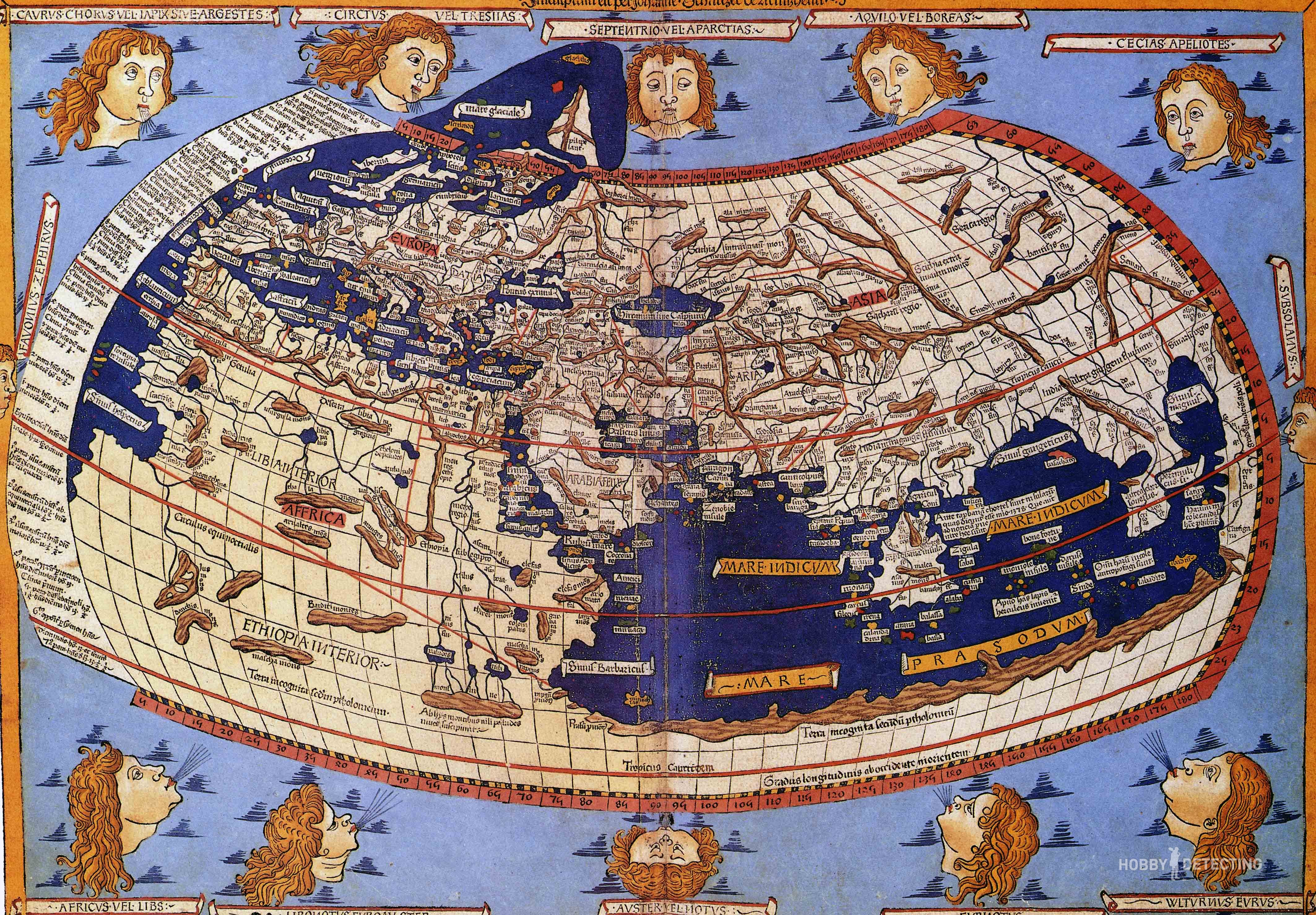
Johan Schnitzer’s map 1482, compiled from Ptolemy’s Cosmography Photo: wikipedia.org
Claudius Ptolemy, an ancient Greek scientist astronomer and mathematician who lived in the 2nd century AD. created a map (cosmography) of everything known to Europeans at that time in the world. The map included the European continent, northern Africa, Asia, India, China and Scythia with Sarmatia. Therefore, cartographers of the 15th century, in the absence of reliable information in the maps of that period, indicated data relating to the 2nd century. And Ptolemy’s map of Africa was relevant back in the second half of the 18th century. The original Ptolemy’s Map was lost, but thanks to the surviving text description “Guide to Geography”, which contained a description of more than 8,000 cities with geographic coordinates. Yes, yes, in the second century AD, geographic coordinates of the area were known and widely used. So, based on the indications of geographical coordinates in 1466, the German monk Nicholas Germanus restored the graphic image of Ptolemy’s map. Ten years later, Hermanus’s graphic materials were engraved and printed in an edition of 500 pieces. Subsequently, over the next century, the map of Ptolemy (Hermanus), having undergone several editions, was repeatedly republished. And, as we can understand, all European cartography began its journey precisely with Ptolemy’s map. It is for this reason that if the cartographer did not have modern data on a particular territory of Eurasia, in this case, information from Ptolemy’s map was applied to the new map. This is where the lands of the Scythians and Sarmatians appeared on the map of Eastern Europe in the 16th century.
Sebastian Munster’s General Cosmography, published in 1550, turned out to be the most profitable book in Europe after the Bible for several decades. It was republished, printed and copied many times. Maps from the Munster cosmography were used by other cartographers to publish their own cosmographies and atlases. The commercial success of cosmography for many centuries determined the interest of publishers in geographical maps, atlases and travel diaries.
Maps of Russia created by foreign travelers.
Содержание статьи:
Well, what can I say? At some point, the territory of present-day Russia became interested in foreign merchants, which, accordingly, became the reason for the appearance of the first more or less accurate maps. And this happened during the reign of Ivan the Terrible. The Russian kingdom was in constant war with all its neighbors. At the same time, England, after the victory of Protestants over Catholics, was also in complete trade isolation. Constant wars required money, and if in Russia they could raise taxes for this, or confiscate the property and lands of another traitor boyar, then in England raising taxes was prohibited by law. And they tried in every possible way to develop foreign trade. Spain established a naval blockade and the main export product – woolen fabrics – remained unclaimed. Moreover, the passage of English ships to the Mediterranean Sea was closed. Then the British decided to explore the northern sea route. Is it possible to get to China this way? It turned out that it is impossible. Then English merchants began to establish business and political contacts with the government of Muscovy. And this desire turned out to be mutual.

Map of Muscovy by Jenkinson. The first English edition of the map was discovered in 1987 in Poland. Now the original map is kept in the library of the University of Wroclaw.
The Russian kingdom, after capturing the Kazan and Astrakhan kingdoms, established complete control over the trade route “from the Varangians to the Persians.” Now goods from the northern regions of Russia could freely reach the Persian consumer. Well, or almost unhindered. The main thing is that along the route of the trade caravans it was possible to deal with robbers and numerous extortions of local princes, murzas and atamans. On the other hand, due to the fact that Russia seized Kazan and Astrakhan from the Ottoman Empire, they responded by announcing sanctions on all goods from Muscovy. And since the Russian kingdom was constantly at war with its neighbors, the issue of foreign trade was always acute. In old Europe, in the event of a war between neighboring states, trade relations were resolved with the help of Jewish communities. It didn’t work out that way for us, and therefore, when English merchants appeared before the king with a proposal to establish trade, an idea arose. Why don’t the British help establish trade with Persia and the Ottoman Empire? These are, let’s say, convenient intermediaries.
The British opened the Moscow Company in Moscow and began systematic development of the territory. Exactly how many sales agents of the Moscow company permanently lived and worked on the territory of the Russian Empire is unknown, but they conducted trading business very successfully. The British had a monopoly on trade in Russia for more than a hundred years, from 1551 to 1698. And we can understand that the benefit was two-sided. But this raises a good question. How did the British swim and then ride on a sleigh to Moscow? ? What motivated them, and who gave the money for this movement? And a lot of money.
For expeditions of this kind, money in Britain was given out by various kinds of societies, in our case it was the “Trading Company of Merchant Travelers for the Discovery of Lands, Countries, Islands and Unknown Places.” And this company’s interest was quite rational. England persistently sought the opportunity to reach China by the northern sea route. Some ancient works on geography stated that one could sail to the treasured China along the Ob River. In the Italian printed edition of “The Book of the Muscovite Embassy to Pope Clement VII” of 1552, it was told from the words of a Russian diplomat that from Muscovy one could sail to China by ship. All this and a number of other informational reasons served as the reason why the British arrived in Muscovy to Tsar Ivan the Terrible. The British were looking for a route to China not yet discovered by Europeans.
For this purpose, in search of a way to China, the English ambassador Anthony Jenkinson, having secured letters of safe conduct, walked along the Oka and Volga to the Caspian Sea, from there to the Aral Sea, there with several companions they joined a caravan of merchants and with them the British reached the city of Bukhara. And there two bad news awaited them. The first is that the path further is closed due to the outbreak of war. And the second is that no one in these parts is interested in English woolen fabrics. Bukhara merchants did not want to buy them even at a reduced price. The British managed to leave Bukhara a week before the siege of the city began, and when the ambassador returned alive and well to Moscow, this greatly surprised Tsar Ivan the Terrible.
In just a few years of being in Russia, English trading agents compiled a detailed description of all trade routes along the rivers and cities of the Russian kingdom. They never found the way to China, however, on the map compiled by Anthony Jenkinson, the myth that the Ob River originates in China was visually enshrined. And here we can assume that either the British did not believe the Russians, who claimed that there was no river route directly to China, or the British thought that the Russians had never found it. Or, what is more likely, this “error” was put on the map deliberately in order to stir up investor interest in continuing to finance the research and travel of the Moscow company. After all, according to biographers of Anthony Jenkinson, the ambassador, traveler and merchant died as a very wealthy man.
What can we say to summarize this chapter? Jenkinson’s map was included in the first geographical Atlas “Spectacles of the Earth’s Circle”. By the way, it was from this publication that all collections of maps began to be called not cosmographies, but atlases. As we can guess, «The spectacle of the circle of the earth» became the most profitable and expensive book of its century, after the Bible. And the maps published in this publication became the canon for other publishers and cartographers for many decades. And also, on Jenkinson’s map, Ivan the Terrible is sitting in a tent and the signature on him is “Great Emperor of Russia.” In Europe at that time no one was called an emperor. So we can confidently assume that this point was brought out in the form of a good diplomatic gift towards Tsar Ivan. Well, you know, as they usually say when giving compliments, “It’s a trifle for us, but it’s nice for you.” But in our time, from this inscription, supporters of historical conspiracies have lost peace and peace of mind, because look when Rus’ was an empire. Our history was stolen!!! Guard!!!
Maps (drawings) compiled by order of the rulers of Rus’.
Large drawing of the Russian kingdom. They talk a lot about him, write about him and sometimes even make videos. The scientific community does not have a generally accepted point of view and understanding of what it is. There is no information about when and by order of which king this drawing was made. But there is an assumption that the order to create a single map (drawing) of the entire Russian kingdom was issued by Tsar Ivan the Terrible. There is no information about when and in what form the drawing was made and delivered to the customer. Then, during the reign of Tsar Fyodor Borisovich, a message appears that the Big Drawing, which was kept in the Discharge Order, became dilapidated and worn out so that it can be read with difficulty, and the names of individual tracts cannot be read at all. Then the king gives orders to correct and edit the Big Drawing. The work of editing and updating the Great Drawing was completed under Tsar Mikhail Romanov. The Drawing indicated the locations of 880 rivers, 400 cities and approximately 70 lakes. Since the drawing was kept in a single copy, only its description according to the Book of the Large Drawing has survived to this day. This is also a very interesting document, we will analyze it.
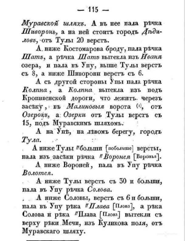
Excerpt from the Book of the Big Drawing.
But first, let’s try to understand why this Big Drawing was needed? There is also no exact information, as well as an understanding of what it really was for? Based on the information that the drawing has been fairly worn out from use over three decades, we can assume that it was indeed often used, but for what and for what purposes? It is not clear. There is a version that the drawing was needed for public administration. What is meant by the term public administration is also unclear. Moscow at that time had only one interest in its territories – the tax base. The principle of relations between the center and the regions was based on the concepts of the brothers from the dashing 90s. We protect you, you pay us for it. In such a vassal system management model, the development of a region is the problem of the region itself.
There are two options for needing this card. This is political weight and trade. Politics is a delicate matter, and the royal court in Rus’ always understood this. Often entire performances were staged for foreign ambassadors. For example, the same Jenkinson wrote down in his travel notes a story about how Tsar Ivan Vasilyevich received him at dinner. In fact, it was a dinner, but more than two hundred people were present, and the dinner was served by “princes.” The servants at the feast were dressed in such a way that foreign guests mistook them for noble persons. So, the tsar informed Jenkinson through an interpreter that at the same time, two thousand Tatar horsemen were having lunch in the neighboring chambers, that they had recently arrived in Moscow, swore allegiance to the tsar and would soon leave to fight for the tsar in Livonia. Jackinson did not see the “knights” themselves, but, as we can guess, the ambassador understood the message. The entire trade route from Moscow to the Caspian Sea is under the control of Tsar Ivan Vasilyevich. And in this regard, a visual plan or map of the entire Russian state was simply necessary during diplomatic conversations. European ambassadors came to Muscovy by land, crossing vast expanses. And so, when the Tsar or other sovereign people showed them a map, the European ambassadors began to realize how vast the lands governed by the Russian Tsar were.

“Ivan the Terrible shows treasures to the English ambassador Horsey “, 1875 artist Alexander Litovchenko.
Another and most likely version of using a large drawing is to use it for trade relations. The experience of trade with the British was very successful and positive. Therefore, foreign traders in the Russian kingdom were favored and their work was facilitated in every possible way. The free market and the principles of healthy competition have always benefited the economy of the country and regions. Being a crossroads of trade roads has always been beneficial at all times. Therefore, as we can assume, the Big Drawing was a standardized map of the Russian kingdom. According to it, foreign merchants could make copies for themselves and freely travel with and for goods throughout the territory of the state.
Let’s move from theory to practice. As a big fan and supporter of instrumental search, I considered all three described map options as an opportunity to find interesting information for myself. To be honest, I didn’t find it. Although someone from other regions may find the Book of a Large Drawing interesting. And here’s the plan. The book lists in detail, not entirely accurately, but in some detail, all navigable rivers and rivulets, with the approximate location of their confluence with the main channel of the main river. So this is where the interest may lie? The fact is that since the time of Ivan the Terrible, the landscape of central Russia has changed quite a lot. And many rivers ceased to simply exist, others turned into swampy streams. This happened due to deforestation and agricultural development of land. In dense forests, moisture evaporates more slowly, so streams feed rivulets, and rivulets feed navigable rivers. When the forests were cut down, the rivers became swampy and then completely disappeared from the area; in some places they could have simply been plowed up. But once upon a time, people lived and worked along the banks of these rivers and rivulets. And with a detailed study of the Book of the Big Drawing, I think it will be possible to find several interesting places for digging in the Middle Ages.
But this is just my guess, since the Book of the Big Drawing did not give me anything interesting in the area in which I live. But I don’t see any point in searching and going somewhere a hundred kilometers or more away. However, I was able to make one interesting observation about the Book of the Large Drawing. The book from the times of Mikhail Fedorovich copied errors from Jenkinson’s travel notes one-on-one. Description of four settlements along the river. From point A to point B — 30 versts, while in reality 45, from point B to point C – 60 versts, while in reality 30 and from point C to point D – 90 versts, and in reality about the same. Jenkinson’s travel description fully corresponds to the Big Drawing road guide. From which we can confidently conclude that the Big Drawing was based on Jenkinson’s map.
Despite the fact that the original of the large drawing has not survived and its fate is generally unclear, Geritson’s map of 1613 has survived to this day. On the map itself there is a description that it was compiled by the Dutch cartographer Hessel Geritson based on the map of Muscovy by Tsar Fyodor Borisovich Godunov. So with a high degree of probability we can say that Geritson’s map is the Big Drawing.
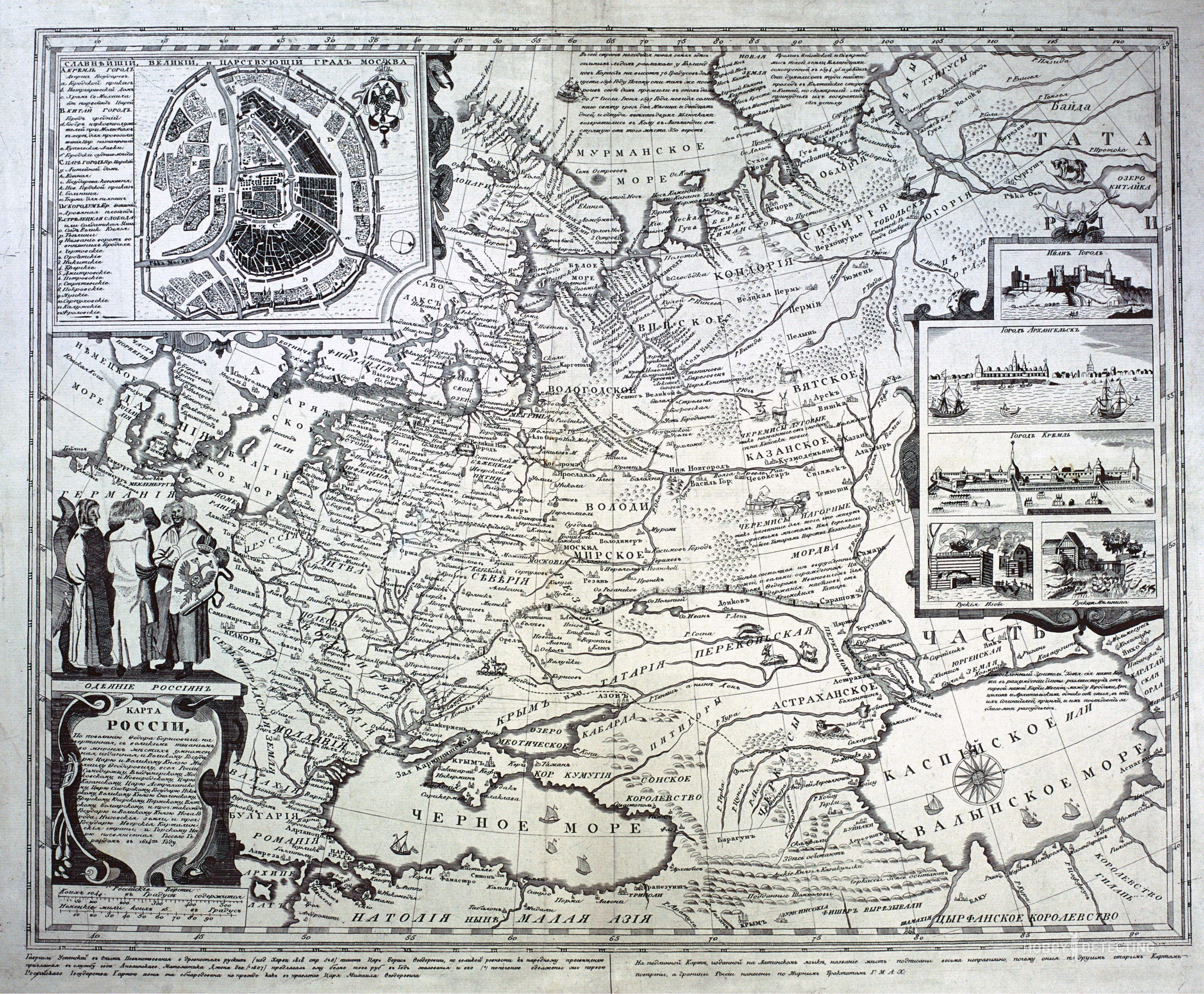
Russified copy of Geritson’s map
What would I like to say in conclusion of this article? Studying ancient maps is really exciting, because in addition to the maps themselves, you begin to study the accompanying descriptions, travel notes of foreign travelers and other documents. And this is where that very experience is gained, that minimum required amount of knowledge, even if this knowledge is theoretical, but in the future it is this knowledge that can help in searching and finding a very interesting and tasty place for a cop. A place that no one has ever found before.
P.S. While preparing this material, I found a very interesting document. In which, among other information, it is reported that in 1837 statistical committees were created under the Ministry of Internal Affairs of the Russian Empire. One of the tasks assigned to these committees was the widespread collection and systematization of information about memorable places, “monasteries, churches, castles, houses, water pipelines, bridges, ruins of walls, remains of ancient roads and other ancient monuments, remarkable either for their historical events, or for any particularly important incidents.” But that will be a completely different story, so I wish everyone good luck and thank you for reading our site.