
I know that among the total number of diggers there are many decent and honest people. People who, in their favorite hobby, try to follow the letter of the law as much as possible and not violate its fundamental principles. Namely, never, under any circumstances, dig at archaeological sites. I am one of these citizens. And the first thing I began to study, after the instructions for the device and the legislation of the Russian Federation, was a digitized ACR for our region, downloaded from the Internet, a scan of a printing publication for 1995. Anyone who has at least once tried to determine the location of an object using the AKR, for a good or, on the contrary, for a detrimental purpose, knows that reading this very map is a mysterious rebus, a quest and a puzzle in one set. A natural question arises: what to do?
About the geoinformation system “Archaeological Monuments of Russia”
Содержание статьи:
Not long ago, in a conversation with the owner of our website, I learned that in a number of European countries, electronic maps of archaeological sites have been in operation for several years and are available to everyone online. Maps with clear coordinates based on the Google Maps resource and contour lines of boundaries on the ground. An interesting, visual and absolutely useful thing, especially for those countries where instrumental search is permitted by law. So I wondered, what about us? It seems like the digital economy, the digital government, and the declared innovations in all areas of government. After a short search for information (Google to the rescue), I was surprised to learn that back in 2016, the Institute of Archeology of the Russian Academy of Sciences announced the creation of a unified geographic information system “Archaeological Monuments of Russia.” What is it and where can an inquisitive layman look for it? We will now try to figure it out.
In 2016, a number of domestic online media published publications about the creation by Russian scientists of the Geographic Information System “Archaeological Monuments of Russia”. Really? I thought, and we decided to finally organize the entire archaeological economy. And how beautifully the news about the created system was titled “Scientists of the Institute of Archeology of the Russian Academy of Sciences have developed and launched the geoinformation system “Archaeological Monuments of Russia” – the first electronic archaeological map of a national scale in our country, which contains data on more than 15 thousand objects.”
I began to understand the topic and with each new site I opened, my ardent youthful enthusiasm faded, cutting off in geometric progression. But let's take things in order. In fact, on the Internet, when you enter “geographic information system archaeological monuments of Russia” into the search bar, standard news materials come out that link to the original source. The primary source is the website of the Institute of Archeology of the Russian Academy of Sciences. When you click on the link, the site displays 404, such a page does not exist. Mmm-hmm? I thought unobtrusively. Probably, the IA RAS website was updated and this page was moved. But when we enter a similar query in the search bar of the site, we are not given anything. It’s strange, but this happens, I know it myself, search engines on budget sites may not work, it happened, I encountered it more than once. I went to the site’s news feed and scrolled through all the news for 2016. It should be noted that this site is generally rather bad with news and in general with the “Media about us” section, but even in the “array” that is there, I did not find news about the geographic information system.
Well, there is information that this system was developed by scientists with money from a grant from the Russian Science Foundation. I find a website and try to find information about the project for which funds were allocated. The site has an interactive classifier for searching information about completed projects. Everything is fine, I entered the project data, the “search” button lights up, I press it and, to my disappointment, the search for projects on the site does not work. An attempt to find a project manually using the 2015 list was unsuccessful, because it is like looking for a needle in a haystack. More than 1000 approved and funded projects per year. This was my first experience of such a search, so it was a special pleasure to read what such foundations periodically issue grants for. Here's an example: Comparative historical study of anthropogenic landscapes of various regions using unmanned aerial vehicles (Tambov region and Udmurtia, mid-18th – early 20th centuries). To my great disappointment, during a detailed analysis of the Foundation's website and from other sources, I was not able to find out exactly how many money was allocated for the development of a geographic information system, and it was especially interesting to find out how much they paid for the study of anthropogenic landscapes. But this, as they say, is simple human envy, I couldn’t get such a grant, even though I had sent applications a couple of times with hope for the best, so I need to figure out where this system is now and how can I use it?
I read the available news for 2016 and it contains comments from the creators of the system. In particular, to the question: who, how, and under what conditions will be able to use the geographic information system? The developers respond that this is a “sore” topic, and it would be wrong to put the system in the public domain, since it could be used by looters for personal gain, carrying out illegal excavations at archaeological sites. However, it is possible or even likely that the system will be made available in two versions. Free but limited access, where general available data on archaeological sites will be visible, and key access for specialists; in this option, full versions of the service will be available.
Well, that’s it, at this stage I completely stopped trying to figure it out and continued looking for something. All mentions on the Internet about the geographic information system are limited to 2016, after which no one has ever written about it. On the website of the Institute of Archeology, the information was deleted, there are no links to the project itself, and there are no users who saw the system in operation, except for the developers themselves. All that was left online was a Google map with a certain set of points. Each digger makes such maps independently, without any grants, during the winter, planning trips for the coming season. In my personal opinion, this whole project turned out to be just a waste of money from a grant; I was unable to find information in the sources about why and generally what goals the developers were pursuing. And this is very sad. Why? Let's look at the world experience in using and applying similar geographic information systems for recording archaeological sites.
international experience
Example No. 1. Great Britain. Website historicengland.org.uk. This is the interactive portal of the Heritage Commission for England. The commission itself was created in 1983 and, thanks to its meticulous work, a national register of cultural, historical and archaeological monuments was compiled. About ten years ago, all data on protected objects was placed on an interactive site map. Thanks to a convenient and understandable interface, anyone can receive detailed and comprehensive information about the location of protected sites, monuments and territories in the desired region of Britain without registration or SMS or receiving any administrative access keys. The site does not freeze, does not glitch, and works smoothly on its own map. Having selected the object you are interested in, click to go to the card page of the archaeological or historical object, where its coordinates are clearly assigned, on a separate map the topographic boundaries of the object are indicated, the owner of the land plot on which the object is located, as well as the protective status.

General view of the map service of the website of the Department of Historical Heritage of England
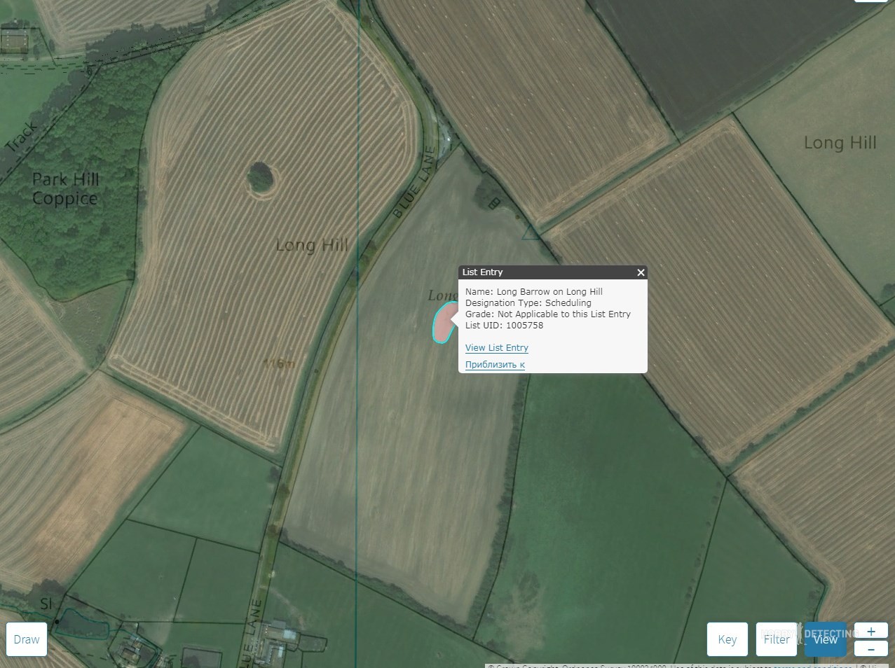
This is how you can clearly and clearly see the boundaries of the archaeological site on the map.

A brief description of the object, clear and useful even for a sophisticated tourist. Google translate translation)))
Among other things, the portal is developing tourism in Britain and with its help anyone can find out where and when various events, festivals, or local holidays are planned. You can find a hotel in a historical building, a restaurant and a museum in the area you need.
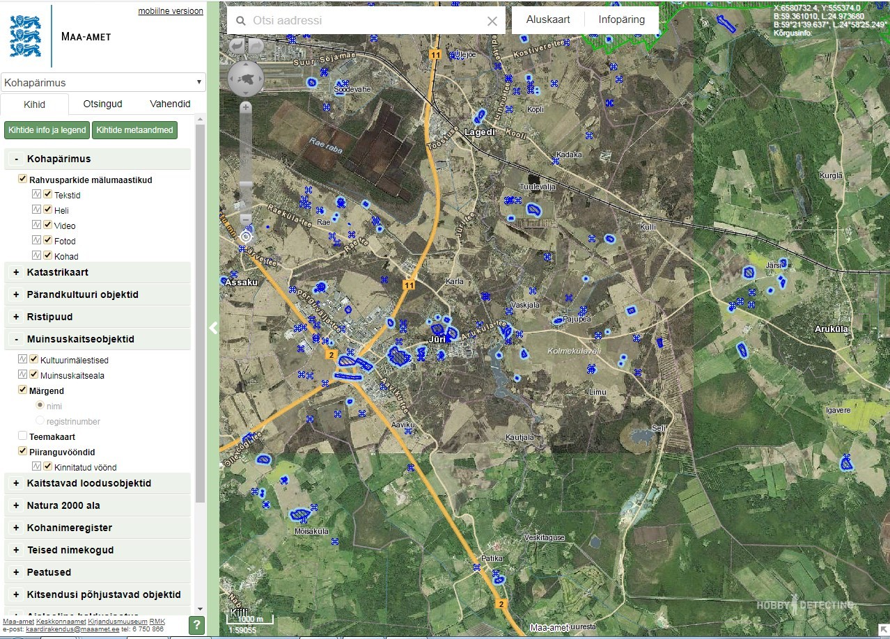
I liked the Estonian version of the geographic information system better, although it is more difficult to use. Still, the British created their resource more for tourists, and there is more information for specialized use. although the boundaries are visible and it’s clear on the map where you can’t dig.
Example No. 2 Estonia. Website of the Department of Land Management of the Ministry of the Environment. The main functionality of the Department is the registration and conduct of transactions with land plots. This is a multidisciplinary Internet portal, among many different useful functions (cadastres, registers, land surveying) there is a map of state-protected land plots. The map is in the public domain and any Internet user can study it freely. All explored and registered archaeological sites in Estonia are shown on the interactive map in connection with a satellite image. Objects are clickable and when you click with the cursor you can see detailed information about each state-protected object. It is also worth noting that the protected area of the facility extends to a plot of land within a radius of fifty meters from the facility itself. As we can see, everything is functional, convenient, accessible and understandable.

This is what a card of an archaeological site looks like in Poland.
Example No. 3 Poland. The material and photographs for this section were taken from the LJ user starcheolog “Field Diary of an Archaeologist.” The Poles are a little more complicated than the previous examples. They do not have an interactive map, and a register of archaeological sites is available for download on the State Department of Historic Preservation website. For more detailed information, please contact the phone numbers listed on the website. Most likely, the service for providing information about the location of archaeological sites is paid, but that is not the point. The example of Poland is interesting because the registration and accounting of archaeological objects has been carried out since the 70s of the last century. During this time, special journals were established in each voivodeship, where data on archaeological sites on the territory of the voivodeship was entered. But most importantly, with each land owner who had archaeological objects recorded on their territory, obligations were concluded to protect the objects.
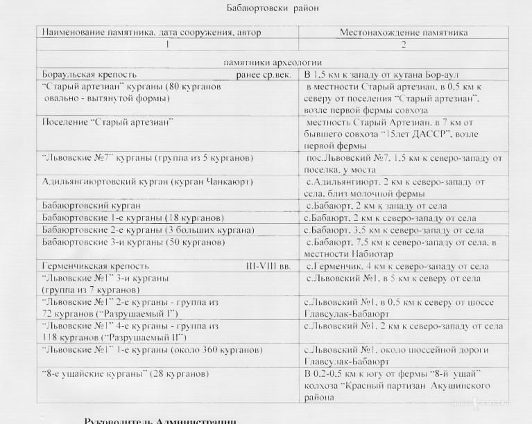
This is how our description of archaeological sites looks like (((

And this is a map from our portal of the register of cultural and historical monuments. If you simply enlarge the map, it does not display a large number of objects. And only with a manual search when you find an object in the registry by parameters, you can see the location of the OKN
And yet, let's look at how it is with us? Website Open data of the Ministry of Culture of the Russian Federation. There is an interactive map in the section “Register of Cultural Heritage Monuments”. Yes, it’s beautifully designed, in the form of a map of some chain store. The points on the map often do not coincide, there is very little information about the object and, most importantly, there are no boundaries on the map. There are cards of archaeological sites, where there are no instructions or even just coordinates of the object itself. The only clickable link leads to the scanned document. These are orders from local self-government bodies or republican authorities to assign the status of a protected monument to some unknown object. In the electronic register itself, only the text from the orders is copied. In general, it’s a complete mess and confusion; for whom and to whom this registry can be useful is also unclear. There is only one plus: access to the resource is truly free. And most importantly, the content of this registry leaves much to be desired. Since only in our village there are two objects of cultural heritage, and within a radius of 20 kilometers there are at least thirty objects of archaeological monuments. This is according to the AKR for our region, published in 1995. In the register I could only find cultural heritage objects. There is no information on the boundaries and a complete list of archaeological sites.
What conclusions can be drawn?
In my personal opinion, the project with a geographic information system either failed, or initially had the goal of simply using funds. All that remains from this project is a beautiful screenshot with Google Maps and dots. It’s a pity that we couldn’t find data on the amount of allocated funds, then we could at least understand how much we can earn from two screenshots.
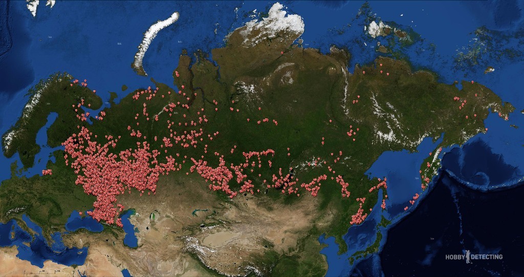
This is what the developers of the geographic information system intended it to look like. The last note about the system itself said that data on 18,000 archaeological sites had already been entered. Photo taken from the news cache page deleted from the IA RAS website
Objects of archaeological heritage are a problem that no one really wants to deal with. I can assume that the functions of registration and compilation of data cards were assigned to the municipal authorities. And on the ground, as usual, citing a lack of personnel, this matter was immediately and thoroughly forgotten.
If archaeologists discover new objects, then in our country there is no regulation or general understanding of how to register and draw up a card of this object. So it’s not clear at all who needs this in principle?
Publication of data on the location of the boundaries of the OAN in map format and on the public Internet is possible only after drawing up maps of the object and working out security obligations for the object with the owner of the land plots.
During the preparation of this material, I read an interesting article about the problem of registering archaeological sites in the Russian Federation using the example of the Primorsky Territory. The article notes that there are 2,700 identified OANs in the Primorsky Territory and not one of them has a correctly filled out passport. None of the objects has clearly defined boundaries.
According to the legislation of the Russian Federation, the boundaries of the OAN are established exclusively during field archaeological work. On average, no more than two open sheets are issued per year for archaeological work per region or region of the Russian Federation. If we take into account that each of these regions has at least 5,000 archaeological sites identified by the AKR, we can imagine how many thousands of years it might take to register the boundaries of the OAN.
In conclusion. Let me be considered a black digger or an illegal archaeologist, yes, this is my hobby, and I do not want to go to sites where exclusively professional archaeologists should and simply must work. I am convinced that here, as in England, archaeological monuments should become the cultural heritage of a particular region, city, village or village. And cultural heritage will help develop domestic tourism. But how can we do this if those who accuse us (the diggers) of destroying and destroying archaeological objects do nothing, absolutely nothing to basicly systematize and record existing and open objects. According to my assumptions, over the past 20 years in our area, about a dozen OANs were destroyed not by black diggers or illegal archaeologists, but by sand miners. But there is no reason to prove anything or simply call the police. How can one explain, even to the owner of the land, that there are objects protected by law on his plot. When the ACR has no legal force. Most of the information and descriptions of objects are hopelessly outdated. Reference points in the form of a water tower or a triangulation point, or a separate building in the village, all of this has been destroyed or dismantled for scrap metal and try to prove that it is from this place that you need to count on the map.
While British Culture Secretary David Lammy called amateur treasure hunters “the unsung heroes of the national heritage.” And all of us are black diggers, looters and destroyers of national heritage.